

Land Survey System: Supporting First Nation Land Governance
A land survey system identifies, describes and locates a parcel(s) of land. Land surveys on First Nation reserve lands are regulated through the Canada Lands Survey System (CLSS). Attributes of the CLSS include:
- authorized by Legislation (i.e. Canada Lands Surveys Act);
- survey standards providing reliability and consistency (i.e. National Standards for the Survey of Canada Lands);
- regulation of survey profession through professional association with a mandate to protect the public, ensure competency of surveyors, and provide accountability through complaints process (i.e. Association of Canada Lands Surveyors);
- process for initiating, reviewing, approving, recording, and archiving of survey records (Canada Lands Survey Records);
- ensures the location and extent of a parcel of land is properly described in legacy documents and marked on the ground, and:
- supports the land registry (Indian Land Registry, First Nation Land Registry, territorial or provincial Land Title Offices).

Effective land governance requires a good understanding of how these three Systems (Registry, Survey, and Management) combine to support a First Nation’s lands.
The combination of the: Land Registry + Land Survey + Land Management = Property Rights System.
All three of these components are independently operated systems having their own sets of policies, guidelines, regulations, records or documents, but they are designed to work together to effectively regulate the use and development of land.
Guide to the Evaluation of Proposals for Resource Centre Survey Contracts
The First Nations Land Management Resource Centre Inc. (Resource Centre) has been granted the authority to issue and manage survey contracts on First Nation land, to support a description of lands being transferred to the First Nation’s administration and control pursuant to the Framework Agreement on First Nation Land Management. The survey contracts that are managed by the Resource Centre are for those surveys that are deemed to be required in order for the Surveyor General Branch to be able to proceed with the preparation of the Land Description for a specific Reserve. Each proposal received by the Resource Centre is evaluated on a number of criteria, such as liaison and involvement with the First Nation, ability to meet the contract timeframes, and experience of the company and/or staff working on the project, all of which are outlined in the Guide to the Evaluation of Proposals for Resource Centre Survey Contracts.
Survey Related Links
National and Provincial Maps of Developmental and Operational First Nations
The Survey Process
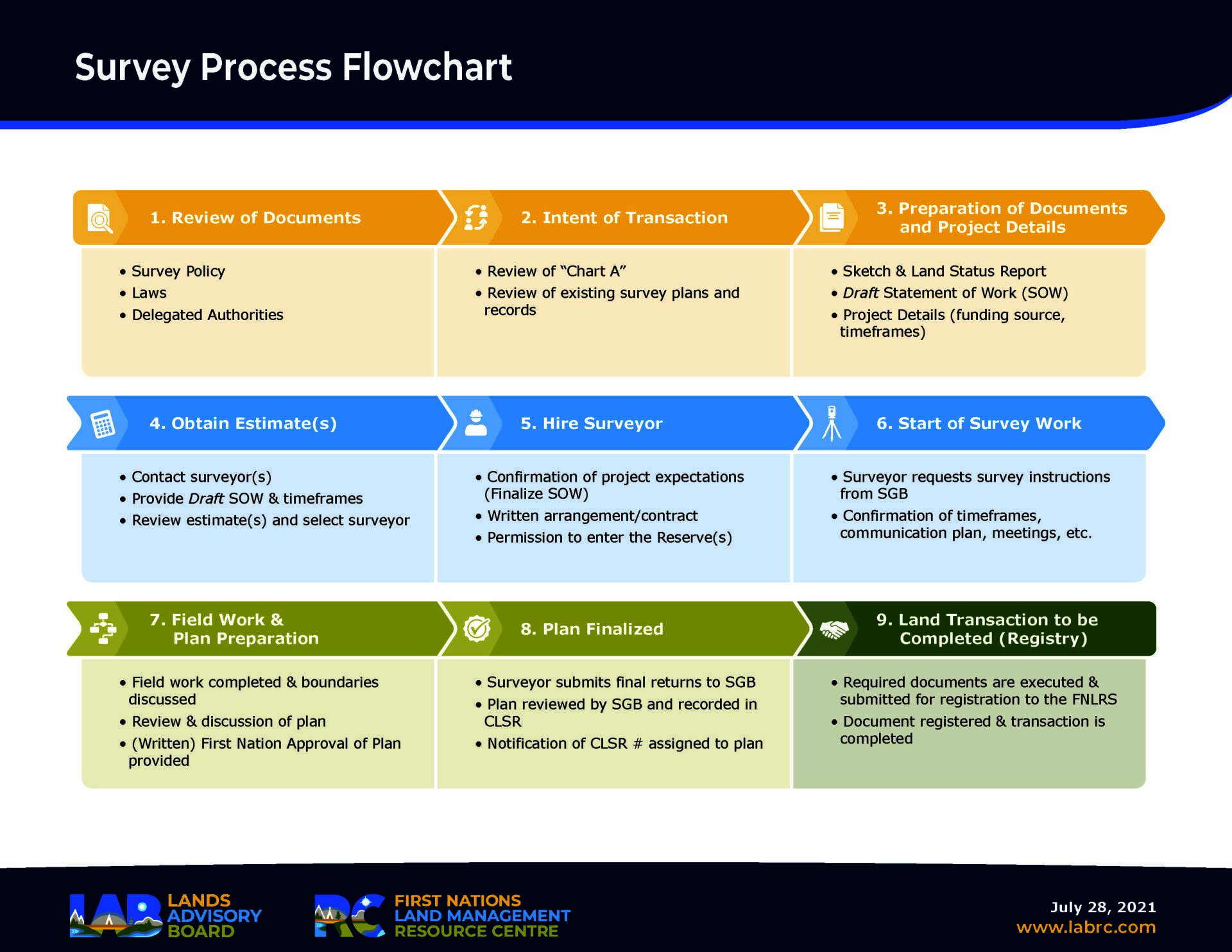
Survey Process Flowchart
Getting a Survey Done
Section 4.1.1 of the Framework Agreement states: Any reserve managed by a First Nation under a land code will continue to be a reserve within the meaning of the Indian Act. The Canada Lands Surveys Act and Canada Lands Surveyors Act and Regulations still apply to lands managed under a land code. The surveys will still be carried out by a Canada Lands Surveyor under survey instructions issued by the Surveyor General Branch, with the survey plan being recorded in the Canada Lands Surveys Records (CLSR). However, a First Nation’s land code may delegate certain authorities in relation to the survey process, such as who has the authority to request a survey, provide permission to enter the Reserve for the survey and approve the survey plan.
Interdepartmental Letter of Agreement (regarding minimum standards for surveys)
NRCAN: Surveying of First Nation Lands Managed under a Land Code.
Research Reports and Land Descriptions
Under Section 5.2 of the Framework Agreement, a First Nation’s land code must contain a description of the lands that are subject to the land code. The Surveyor General Branch (SGB) of Natural Resources Canada prepares this description, known as a Land Description Report.
To prepare the Land Description Report, the SGB will first conduct historical research, review and analyze documentation affecting the exterior boundaries of a Reserve and identify any outstanding boundary-related issues. The SGB compiles the collected information into a report called the Research Report. Once completed, the Research Report’s contents are discussed between parties, the timeframe for resolving issues is discussed, and new surveys are conducted where necessary. The Research Report does not require any formal approvals, as it does not become a public document (not recorded in the Canada Lands Surveys Records). Once all surveys are finalized, and all parties agree to proceed with the next phase of the process, Indigenous Services Canada (ISC) Region will notify the SGB to prepare the Land Description Report.
A Land Description Report contains the description of the Reserve lands subject to a First Nation’s land code and individual agreement, an administrative sketch that visually depicts the lands described, and any additional items/issues regarding the exterior boundaries of the Reserve which are unresolved. All parties carefully review the report to ensure that the extent of the lands described is understood and agreed upon. Both the First Nation and ISC Region provide approval to the SGB to record the Land Description Report in the Canada Lands Surveys Records (CLSR). Once the CLSR number is assigned, the number can be referenced in the land code and individual agreement.
Legacy Projects
Legacy Projects 2021
Legacy Projects 2020
Legacy Projects 2019
The Lands Advisor – Focus on Land Surveys
Scholarships ACLS Foundation Inc.
Geomatics Scholarship Program
Four scholarships of $2,000.00 each are available annually. One scholarship is targeted to an Indigenous student that meets the eligibility requirements.
Objectives:
- Encourage and provide financial rewards to students that are enrolled in a postsecondary institution in the field of geomatics.
- One scholarship is targeted toward an indigenous candidate and one is targeted toward a female candidate, to be selected from eligible applicants.
For more information, please contact:
Rob Pinkerton- Survey Advisor